
GPS tracking uses signals from satellites to determine the location of a GPS-enabled device. A connected tracking device then sends that location information through a communication network to a tracking platform, where it can be displayed on a map, stored as travel history, or used to trigger alerts.
How does your phone know where you are? How can a fleet manager see where a delivery vehicle is? And how can a company track a vehicle or mobile asset even when it is hundreds of kilometres away?
The answer often involves GPS tracking technology. In simple terms, GPS tracking is a combination of location positioning, communication, and software that allows people or businesses to monitor the location and movement of vehicles, assets, or other tracked devices.
This guide explains how GPS tracking works, what happens behind the scenes, how accurate it can be, where it is used, and what its limitations are.
What Is GPS Tracking?
GPS stands for Global Positioning System. It is a satellite-based positioning system that allows a compatible receiver to determine its location on Earth.
GPS tracking takes this basic positioning capability a step further.
For example, a GPS receiver inside a vehicle can determine the vehicle’s location. A connected GPS tracking device can then transmit that location information to a tracking platform. A fleet manager can open the platform and see the vehicle’s reported location on a digital map.
Think of it this way: GPS tells the device where it is. GPS tracking helps communicate that information so someone else can monitor it. A tracking system requires additional hardware, communication, and software beyond GPS alone.
How Does GPS Tracking Work?
The process may sound complicated, but the basic idea is quite simple.
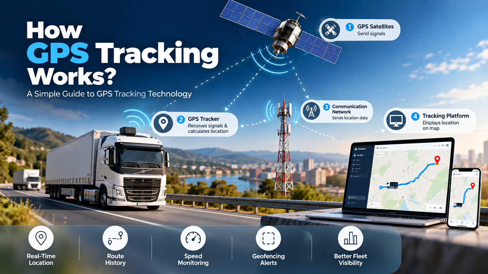
1. GPS Satellites Send Signals
GPS satellites orbit Earth and continuously transmit signals containing information used by GPS receivers. These signals help the receiver determine information about its position.
2. The GPS Tracker Receives the Signals
A GPS tracking device contains a GPS receiver that listens for signals from multiple satellites. Receiving signals from multiple satellites allows the device to calculate its position more accurately than relying on a single satellite.
3. The Device Calculates Its Location
The GPS receiver uses the timing of the satellite signals to estimate its distance from the satellites. By comparing information from multiple satellites, the receiver can determine its position through a process commonly described as trilateration. The result is location information that can be represented using geographic coordinates.
4. The Tracker Sends the Location Data
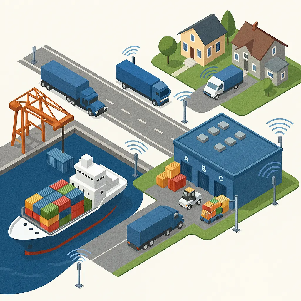
This is where GPS tracking becomes different from GPS positioning alone. A connected tracking device can use a communication network, such as a cellular network, to transmit its location information to a remote server or tracking platform. The exact communication method depends on the tracking device and system.
5. The Tracking Platform Displays the Information
The tracking platform receives the location data and turns it into information that users can understand. Depending on the system, a user may see current or last reported location, vehicle movement, route history, stops, speed information, geofence events, and location-based alerts.
GPS Satellites → GPS Tracker → Communication Network → Tracking Platform → User
What Are the Main Components of a GPS Tracking System?
GPS Satellites
The satellites provide the signals used by GPS receivers to calculate their position.
GPS Receiver or Tracking Device
The receiver collects satellite signals and calculates the device’s location. A dedicated GPS tracker may also collect information such as speed, movement, or device status, depending on its capabilities.
Communication Network
The communication network transfers information from the tracking device to the remote tracking platform. Cellular connectivity is commonly used in connected GPS tracking devices, although the exact communication method depends on the system.
Tracking Software
The software receives and processes the tracking information. It can present the data through maps, dashboards, reports, and alerts.
Mobile App or Web Dashboard
This is the part the user interacts with. For example, a fleet manager might open a dashboard to check where vehicles are located, review previous trips, or receive an alert when a vehicle enters or leaves a defined area.
What Is the Difference Between GPS and GPS Tracking?
GPS and GPS tracking are related, but they are not the same thing.
GPS is a positioning technology. GPS tracking is a broader system that uses positioning information to monitor and communicate the location of a device, vehicle, or asset.
For example, your smartphone can use GPS to determine where you are. A fleet tracking system can use GPS to determine where a truck is, then transmit that information to a platform that a fleet manager can access remotely.
This difference becomes particularly important when evaluating tracking devices. Having GPS capability does not necessarily mean that a device can continuously transmit its location to another person or platform.
How Accurate Is GPS Tracking?
There is no single accuracy figure that applies to every GPS tracking system.
GPS performance can vary depending on several factors, including:
- Quality of the GPS receiver
- Number and position of visible satellites
- Physical obstructions such as buildings and other structures
- Antenna quality and device placement
- Surrounding environment
Outdoor environments generally provide better conditions for GPS positioning than enclosed locations. In cities with tall buildings, signals can be blocked or reflected, which may affect the calculated position.
GPS tracking should not be treated as a perfectly precise location system under every condition. Environmental factors and hardware quality will affect performance.
Does GPS Tracking Work Everywhere?
Outdoors
GPS is generally well suited to outdoor tracking applications such as vehicles, logistics fleets, and mobile assets.
Urban Areas
Tall buildings can obstruct or reflect satellite signals. This can affect positioning performance in some situations.
Indoors
GPS signals may be weak or unavailable inside buildings. Other positioning technologies may sometimes be used alongside GPS when indoor positioning is required.
Underground or Enclosed Locations
GPS positioning can become difficult in underground areas, enclosed structures, or locations where satellite signals cannot reach the receiver effectively.
What Information Can a GPS Tracker Provide?
The exact information depends on the device and tracking platform, but a GPS tracking system may provide:
- Current or last known location
- Location history and travel routes
- Speed and direction
- Stops and idle times
- Time and date information
- Geofence events
- Device status
A basic tracker may provide only location information, while a more advanced system can combine GPS data with vehicle or asset information.
What Are the Common Uses of GPS Tracking?
Fleet and Vehicle Tracking
Businesses can monitor vehicle locations, review routes, and check movement history. This is particularly useful for companies operating delivery vehicles, service vehicles, transport fleets, and commercial vehicles.
Logistics and Delivery
GPS tracking can help logistics businesses monitor vehicles during deliveries and provide greater visibility into transportation operations.
Asset Tracking
Companies can use GPS-enabled devices to monitor mobile or high-value assets that move between different locations.
Personal Vehicle Tracking
GPS trackers can be installed in vehicles to provide location information and trip history.
Public Transportation
Transport operators can use GPS tracking to monitor buses and other vehicles as they move through their routes.
Field Operations
Businesses with employees or teams working across different locations can use vehicle and asset tracking to improve operational visibility.
What Are the Benefits of GPS Tracking?
Better Location Visibility
GPS tracking provides businesses with information about where connected vehicles or assets are located.
Route Monitoring
Historical location data can help businesses review the routes taken by vehicles and understand movement patterns.
Improved Fleet Management
Fleet managers can use tracking information to monitor vehicles and coordinate operations more effectively.
Location-Based Alerts
Tracking platforms can generate alerts when certain location-based conditions occur. For example, a system could notify a user when a vehicle enters or leaves a defined area.
Historical Data
GPS tracking systems can store location history, allowing businesses to review previous trips and movements.
What Is Geofencing in GPS Tracking?
A geofence is a virtual boundary created around a specific geographical area.
GPS tracking systems can compare a device’s location with this virtual boundary. For example, a company could create a geofence around a warehouse. When a tracked vehicle enters the area, the system could record the event or generate an alert. The same principle can be used when a vehicle leaves a designated area.
Define an Area → GPS Determines Location → System Checks the Boundary → Event or Alert
Geofencing can therefore be useful for fleet management, logistics, asset monitoring, and location-based workflows.
What Are the Limitations of GPS Tracking?
- Signal coverage: GPS signals can be difficult to receive in some indoor, underground, or heavily obstructed environments.
- Connectivity dependency: GPS positioning and data transmission are separate processes. A tracker may determine its location but still need a suitable communication connection to send that information to a remote platform.
- Power requirements: Tracking devices require power. Battery-powered devices may need recharging or careful power management.
- Variable accuracy: Accuracy can vary depending on the hardware and surrounding environment.
- Privacy and compliance: GPS tracking involves location data, so organizations should consider privacy, access control, data protection, and applicable laws when implementing tracking systems.
Need GPS Tracking for Your Containers or Fleet?
Klik eSeal combines GPS and RFID technology in electronic container seals designed for sea, road, and rail cargo. Real-time location data with tamper-evident physical security.
Request a QuoteGPS Tracking vs RFID Tracking: What Is the Difference?
| Feature | GPS Tracking | RFID Tracking |
|---|---|---|
| Primary purpose | Location monitoring | Identification and tracking |
| Main technology | Satellite positioning | Radio-frequency communication |
| Common applications | Vehicles and mobile assets | Inventory, products, containers |
| Positioning | Uses GPS signals | Uses RFID readers and tags |
| Coverage | Suitable for wide geographical areas | Depends on the RFID system |
| Typical environment | Outdoor and mobile tracking | Warehouses, supply chains, controlled areas |
Note: GPS and RFID are often complementary rather than competing technologies.
The two technologies do not always have to compete. In some operations, GPS and RFID can complement each other. For example, GPS could be used to track a vehicle while RFID could identify specific goods or containers being transported.
For a deeper explanation of RFID, see: What Is RFID Technology?
How Often Does a GPS Tracker Update Its Location?
A GPS tracker does not necessarily send its location to the tracking platform every second.
The update frequency depends on the device, configuration, tracking mode, communication network, power requirements, and service setup.
This creates an important distinction:
- GPS location calculation is the process of determining where the device is.
- Location reporting is the process of sending that information to the tracking platform.
A device may calculate its position frequently but transmit updates at a different interval.
Frequently Asked Questions About GPS Tracking
How does GPS tracking work?
GPS tracking uses satellite signals to determine the location of a GPS-enabled device. A connected tracker can then transmit that location information through a communication network to a tracking platform.
How does a GPS tracker find its location?
A GPS tracker receives signals from multiple GPS satellites and uses the timing of those signals to calculate its position.
Does GPS tracking require the internet?
The GPS receiver itself does not require an internet connection to calculate its position. However, a connected tracking system needs a communication method to send the location data to a remote platform.
Does a GPS tracker need a SIM card?
Many connected GPS trackers use cellular networks and therefore may use a SIM or embedded cellular connectivity. However, the exact setup depends on the tracking device and communication technology.
How accurate is GPS tracking?
GPS accuracy varies depending on the receiver, satellite visibility, environment, antenna, device placement, and other factors. There is no single accuracy level that applies to every GPS tracking system.
Can GPS tracking work indoors?
GPS signals can be weak or unavailable indoors. Indoor positioning may require other technologies or additional infrastructure.
How often does a GPS tracker update its location?
The update frequency depends on the tracker’s configuration, communication network, power requirements, and tracking service. Different devices can use different reporting intervals.
What is geofencing in GPS tracking?
Geofencing is the use of a virtual geographic boundary to trigger an event or alert when a tracked device enters or leaves a defined area.
Can GPS tracking work without cellular connectivity?
A GPS receiver can determine its position without cellular connectivity. However, a tracker generally needs some form of communication connection to send that location information to a remote tracking platform.
Conclusion
GPS tracking may look like a simple dot moving across a map, but several technologies work together behind that dot.
GPS satellites provide positioning signals. The GPS receiver uses those signals to calculate its location. A connected tracking device can then transmit the location information through a communication network, and tracking software turns that data into maps, routes, alerts, and reports.
That combination makes GPS tracking useful for fleet management, logistics, vehicle monitoring, asset tracking, transportation, and field operations.
At the same time, GPS tracking is not perfect. Signal conditions, device hardware, connectivity, power, and the surrounding environment can all affect how the system performs.
Understanding these differences helps businesses choose the right tracking technology for the problem they are actually trying to solve.
Sources: U.S. Department of Defense GPS.gov; European Global Navigation Satellite Systems Agency (EUSPA); National Coordination Office for Space-Based Positioning, Navigation, and Timing.